 |
|
If you ask any traveler what's on their travel bucket list, you’ll often hear common sights like Petra or Easter Island (for good reason— those are incredible destinations!) but for as long as I can remember, I’ve been fascinated by the Panama Canal. It’s been on my bucket list for years. It’s such an easy, quick flight from the US yet I’ve never gone until now. I don’t know what it is specifically about it that continues to draw me towards it. The Panama Canal is not as mysterious as the Easter Island moai, Lalibela’s rock-hewn churches, or the mesmerizing city of Petra built completely into rock, but Panama is somewhere I’ve always envisioned visiting. Perhaps it’s the fact that it took more than 40,000 workers (many of whom lost their lives or were permanently injured during construction) to build the Panama Canal. Perhaps it’s the fact that the isthmus of Panama is compact enough to be crossed in one hour (the country is so small it could fit inside South Carolina) yet, despite that, it’s so biologically diverse (Panama’s biodiversity has been said to be three times that of the United States, Canada, and Europe combined). Whatever the reason, I've always wanted to go to Panama— "the place of many butterflies" in the native language.
We set our alarm for 4 AM back in Guatemala. As usual, I checked my phone notifications when I woke up. To my surprise, I saw notifications from Copa Airlines that our flight was delayed. We went downstairs to tell our waiting driver, and agreed upon a pick up time a few hours later so we could wait at the hotel instead of at the airport. The hotel had already prepared a boxed breakfast for us to take on the plane, which we ate as a snack in the room while making some coffee. We went downstairs to breakfast and when we returned to the room, I got a notification that our plane was delayed yet again. I called the airline to try to find out more information (unsuccessfully). I had seen a later flight that day, and was very tempted to change our flight because I was sure that the current flight would be cancelled. We ended up going to the airport anyway, where we were apparently some of the last passengers to check in for our flight. We proceeded to the gate and saw no plane there. We waited, and waited, and waited... no plane came. We never officially got another delayed notification, but it was another 40 minutes past the boarding time before the plane came. When it did come, government officials boarded the plane after all passengers had disembarked. We were told boarding would begin in 10 minutes, so we lined up. Time went by, and everyone was just standing around... it was another 40 minutes before we got on the plane. By the time we took off from Guatemala City, our plane had been delayed a total of 9 hours, which meant we lost one entire day of sightseeing in Panama (we were supposed to arrive in the early morning). Flying over Panama on our descent, we could see ships waiting to enter the Panama Canal and a developed coastline. On the left, we could see a very developed coastline but on the right, it was just forest—city meets nature.
 |
| Quick iphone pic of all the ships waiting to enter the Panama Canal. |
 |
| Descending into Panama. |
When we landed in Panama City (the most cosmopolitan capital in Central America), we made our way through the large airport (which is worse than the Tom Bradley terminal at LAX!) and headed straight to our hotel. By the time we got to the hotel, we put our bags down and then it was time for dinner.
 |
| Our room at the American Trade Hotel. |
 |
| American Trade Hotel, Panama City. |
We went to a Japanese restaurant I had found online, called Hikaru. I was surprised that the Japanese food was so delicious... agedashi tofu, miso ramen, sashimi, sushi, tempura, and mochi ice cream. Our eyes were bigger than our stomachs, but we ate it all since we hadn't eaten anything since breakfast with the flight delay!! Below are a few photos— I was too hungry to take any more!
 |
| Delicious ramen at Hikaru. |
 |
| One of our sashimi plates at Hikaru. |
After dinner, we headed back to our hotel to prepare for our long day ahead, and one of my favorite days in all of my travels.
The following day, with our packed breakfasts in hand, we made our way towards the stunning Amador Causeway. The Amador Causeway is positioned at the entrance to the Panama Canal and is a gorgeous tree-lined causeway that connects the four small islands of Naos, Culebra, Perico, and Flamenco to the mainland. We were some of the last people at the dock, getting a silver wristband as we boarded. When we boarded, all the outside seats had been taken and there were no window seats inside... not a great start to the morning. Our guide assured us that people move around and we'd be able to move to a window seat, but for now we were unable to see anything. We sulked, eating our packed breakfasts and sipping fresh orange juice. When we were about ready to pull away from the dock, I made my way to the upstairs deck to find hoards of people. I stood there by myself, watching the high rises get smaller and smaller as we made our way towards the Panama Canal, a journey that took around an hour in itself. During that hour, I worked my way closer and closer to the front of the ship. When we maneuvered around the small peninsula, we were met by the canal transit authorities. The pilots board each ship before it leaves the terminus to guide it to the Panama Canal.
 |
| Leaving the dock. |
 |
| Our canal transit authorities. |
 |
| Here they come! |
The Panama Canal truly is one of the world's greatest achievements and is one of two most strategic artificial waterways in the world (the other being the Suez Canal). The Panama Canal stretches 50 miles, cutting through the narrow Isthmus of Panama which separates the Pacific Ocean from the Caribbean Sea. It is also where the North American Continental Divide dips to one of its lowest points. The canal doesn't cross the isthmus from east to west, though. Rather, it runs south from its entrance at Colón on the Atlantic side (through the Gatún locks and Gatún Lake) and turns sharply east following a course southeast until it reaches the Bay of Panama on the Pacific side. Prior to the creation of the Panama Canal, ships had to sail around the entire continent of South America (sailing through the dangerous Strait of Magellan) to get from the Atlantic Ocean to the Pacific Ocean and vice versa. Ships sailing from one coast of the United States to the other now save around 8,000 nautical miles of sailing while ships sailing between Europe and East Asia or Australia can save as much as 2,000 nautical miles of sailing. Now, with the creation of the Panama Canal, ships literally "climb mountains" as the locals say. The Panama water lock system consists of lock gates which allow vessels entering the canal to be lifted to a higher level (over the terrain of Panama) in order to reach the other end of the canal, when they're lowered upon return. The canal has three sets of double locks: Miraflores and Pedro Miguel on the Pacific side and Gatún on the Atlantic side. An expansion project in recent years has since added two three-chambered locks which enables larger ships to pass through. In the middle, the ships pass through a huge artificial lake (Lago Gatún). Once a vessel has been authorized to proceed through the canal, it takes about 10 hours to go from one end of the canal to another. Approximately 13,000-14,000 vessels pass through the Panama Canal each year, at a rate of about 35-40 per day across the different lanes. During our partial canal transit, we were on board for nearly 6 hours. It was supposed to take shorter, but at the end we got stuck behind a very slow container ship!
It's incredible to think that the first attempt to build the canal began in 1881 after the Colombian government granted a concession to the privately owned Compagnie Universelle du Canal Interocéanique. The company was financed by French capital from small investors and was under the leadership of Ferdinand de Lesseps. Due to his recent success building the Suez Canal in the Middle East, he was able to attract support for building a canal across Panama. Lesseps was unfamiliar with the terrain in Panama—a tropical jungle rather than an arid desert. There was no sound plan under his direction and disease took a toll in the workers' lives. Progress was slow and incredibly costly. With no foreseeable return on its investment, the French public lost faith in the project. Further financing attempt failed and the company eventually collapsed in 1889. The company reorganized in 1894, but didn't function again until 1898. When the Spooner Act of 1902 passed in US Congress, it authorized purchasing the assets of the French company and building a canal on the condition that a treaty could be negotiated with Colombia. With the backing of the United States, Panama declared its independence and was recognized by the US in November 1903. The Hay-Bunau-Varilla Treaty was then negotiated between the US and Panama, which created the Panama Canal Zone (proclaimed as such in February 1904). President Roosevelt, once committed to the project, supported the building of the canal so enthusiastically that he is thought to be the "father" of the canal, though much of the actual work on the canal was done during the Taft administration. By the summer of 1904, work under American administration was underway. In 1906, Roosevelt and Chief Engineer John Frank Stevens supported the development of a lock-type canal. Included in the proposal was an earthen dam across the Chagres River at Gatún. The dam created what was then the world's largest artificial lake and, at the same time, brought the Chagres River under control. By then, American medical staff understood how tropical diseases were transmitted during the French construction and understood how these diseases, and as a result the fatalities, could be controlled. Even so, over 5,000 workers died during the American effort.
At times, more than 40,000 people were employed by this massive project. Laborers were typically from the West Indian islands of Martinique, Barbados, and Guadeloupe, whereas many of the engineers and tradesmen were from the United States. During construction, railroads and heavy machinery were crucial. More than 100 steam shovels were used to cut the Gaillard Cut, which was one of the most difficult and challenging sections of the entire canal project due to the unpredictable earth on the hillsides. Workers used rock drills, dynamite, and steam shovels to remove as much as 96 million cubic yards of earth and rock as they lowered the floor of the excavation. Despite countless challenges, the canal was opened to traffic on August 5, 1914... more than three decades after the first attempt to build the canal had begun. Following the Torrijos-Carter Agreements, absolute control of the canal passed to Panama on December 31, 1999. It is now managed and operated by the government-owned Panama Canal Authority.
Enough history... Back to the sightseeing! To even get to the Panama Canal, we first had to sail through the Port of Balboa at the mouth of the Panama Canal as we were entering from the Pacific side. The port consists of 19 berths, located on either side of the canal and is able to accommodate general, bulk, container, and passenger vessels.
 |
| Passing underneath the Bridge of the Americas, which connects the north and south American land masses. |
 |
| Sailing through Balboa Port. |
 |
| Balboa Port. |
Ships don't enter the Panama Canal for free, though. The toll amount depends on various factors including vessel type (tankers, chemical tankers, dry bulk carriers, container ships, cargo ships, vehicle carriers, passenger ships, etc), lock type (Panamax or Neopanamax), capacity, the number of containers or passengers onboard, overall ship length, and overall ship width. On top of the tolls, the ships also need to pay for tug assistance, linehandlers, locomotive wires, canal inspection, and other smaller fees that are built in when calculating the overall amount. The largest cruise ships pay more than $300,000 USD per Panama Canal transit. On the other hand, the cheapest toll ever paid was 36 cents. In 1928, American travel writer Richard Halliburton swam through the Panama Canal... imagine that! As we approached the Miraflores locks, I positioned myself on the bow of our ship. There's a no standing rule in the front, but since they never mentioned no sitting, I asked the people sitting on the bench behind me if they minded if I sat on the floor. Of course they said no, since I wasn't obstructing their view but I wanted to be polite in doing so. There I sat, feet dangling through the rails, photographing from the best possible spot as we followed the Virgen Del Cisne through the locks. Only two other people followed my lead by sitting in the front! Thankfully, it was still pretty early in the morning and the heat and humidity hadn't quite picked up. Not to mention, there was a decent breeze sitting so close to the front of the ship.
 |
| Waiting for the ship in front of us to center itself within the canal. |
 |
| The ship ahead of us is escorted by several boats to line up with the canal. |
 |
| Now centered, it's our turn to enter the canal. |
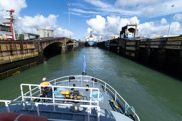
When we entered the locks, I was blown away. The canal locks are of uniform length, width, and depth and are built in pairs to permit the simultaneous transit of vessels in either direction. Each lock gate has two leaves 6.5 feet thick, set on hinges. The gates range in height from 46-82 feet and their movement is powered by electric motors in the lock walls (which are operated from a control tower positioned on the wall that separates each pair of locks). Also operated via the control tower is the flooding or emptying of the lock chambers. The lock chambers are 1,000 feet long, 110 feet wide, and 40 feet deep. Ships are typically guided by electric towing locomotives, which operate on tracks on the lock walls and serve to keep the ships centered within the lock. Before a lock can be entered, a fender chain (stretched between the walls) must be passed. The chain drops into its groove at the bottom of the channel if everything goes according to plan. If the ship is moving too quickly, the chain instead remains stretched and will slowly release automatically until the vessel has been brought to a stop, protecting the locks in the process.
 |
| Entering the Panama Canal! |
 |
| Canal workers on both sides threw cable cords to the ship in front of us. We were just tied with a rope that they threw down to us. |
The locomotives are fascinating in their own right—they're referred to as "mules". Built by General Electric, there were once more than 100 of these mules operating the Gatún, Pedro Miguel, and Miraflores lock stations. The mules operate simultaneously, one on either side of the ship on different tracks of the Panama Canal Railroad, creating tension for the steel cables that keep the ship centered within the narrow channel. Ships passing through have as little as two feet of clearance on each side, so these locomotives are crucial in the safe passage of ships. The engineering is incredible too, considering the mules need to ascend and descend according to the locks... the Gatún locks lift/lower approximately 85 feet!
 |
| The locomotive on the left side of the canal wall once we were raised almost all the way. |
 |
| The locomotive on the right side of the canal wall once we were raised almost all the way. |
 |
| View of the control tower. The locomotives have to climb or descend this hill depending on the direction the ship is going. For us, they had to climb it. |
In addition to the building of the canal, the invention of the locks, and the engineering of the locomotives, it's also incredible to think about the water levels and how those change. From the Atlantic side, ships enter the first of three Gatún locks where the chamber fills with fresh water from Gatún Lake. The water from the lake rushes through the 20 holes in the chamber floor, taking about 8 minutes for the chamber to fill completely and raise the ship. The process is repeated two more times until the ship is level with the lake. It then travels through the lake, where the Pedro Miguel locks are waiting at the other end. The ship gets lowered to the level of Miraflores Lake, passes through the Miraflores Locks, and gets lowered to the Pacific Ocean. Approximately 26 million gallons of Lake Gatún water ends up in the ocean each time a ship passes through one end of the canal, making a total of 52 million gallons released into the ocean for a complete transit. We could literally see swirls of water as the ship was slowly raised to the top of the canal wall.
 |
| Tying us up. That's my foot in the lower left, ha! |
 |
| Here comes the water! You could see it swirling around us. |
 |
| Almost there!! |
 |
| Fully raised. |
Below is a great diagram showing the levels of the locks.
... and a fun little sign we passed by made from Panamanian flags.
Below are some photos of the lock gates...
 |
| The Miraflores locks are closed behind me. You can just barely make out the two canal lanes in the background. |
 |
The canal lanes we had just previously passed through when we were raised.
|
 |
| Closed Miraflores locks. |
After passing through the Pedro Miguel locks, we passed under the Centennial Bridge, which was built to supplement the overcrowded Bridge of the Americas and to replace it as the carrier of the Pan-American Highway. It opened in 2004 and became the second permanent crossing of the canal. Shortly after passing through Centennial Bridge, we disembarked in Gamboa and drove back to Panama City to have empanadas.
 |
| Looking back towards Centennial Bridge. |
After having some empanadas, we made our way back to the Amador Causeway to visit the famed Biomuseo. Designed by renowned architect Frank Gehry (it's his only work in Latin America), the Biomuseo is a fabulous museum focused on the natural history of Panama and the biodiversity found in the country. There is a beautiful outdoor atrium covered by colorful metal canopies and inside, there are eight permanent exhibits.
 |
| The outside of the Biomuseo from the pathway that leads up to it. |
When you first enter, there are dioramas of some of the wildlife found in Panama followed by an immersive media room where a video plays on the walls, floor, and ceiling. You're surrounded by ants walking underneath you, birds flying, thunder crackling in the sky, and more. You then enter a room explaining the foundation of Panama, passing geological excavations and rocks before seeing the ancient animals of the isthmus. There are giant animal sculptures everywhere!
 |
| Animals were once massive... |
 |
| Some of the animals that were found in Panama. |
Passing back outside, there are columns full of information about the history behind Panama and its people. Going back inside, you're immersed in the flora and fauna with more giant sculptures, pictured below. There's even small aquariums highlighting the biodiversity of the ocean life found here!
The museum even had a megalodon jaw (the world's largest shark). It was a thoughtfully curated museum with tons of information to absorb. It's difficult to take it all in!
Following our museum visit, we stopped for a quick photo at the Panama sign... a memory for one of our new favorite countries!
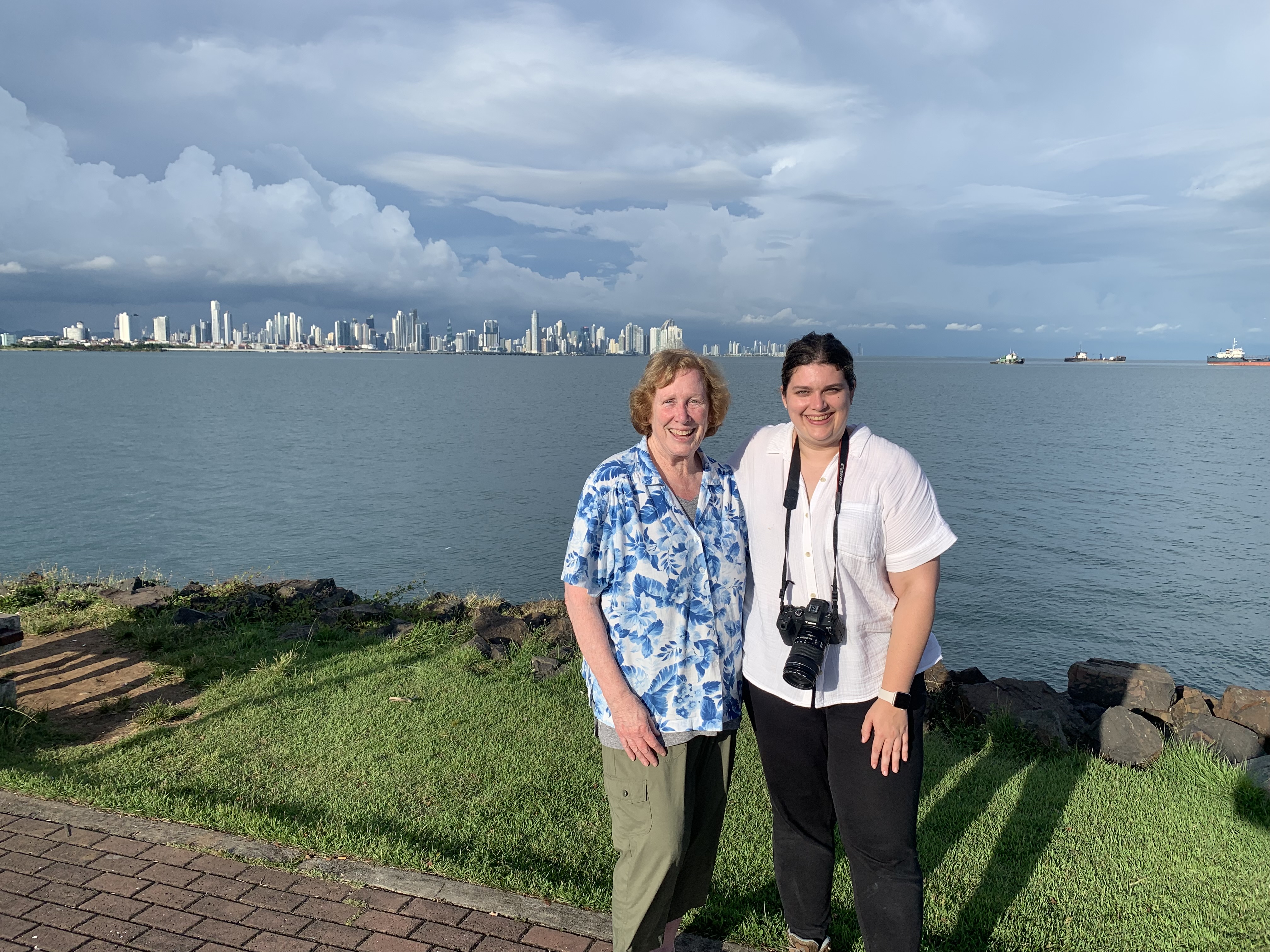
We then took a short stroll on the Amador Causeway which has become one of my all time favorite walking paths in any country. It. Is. Stunning.
 |
| The most picturesque spot! |
 |
| The Amador Causeway with storm clouds rolling in. |
 |
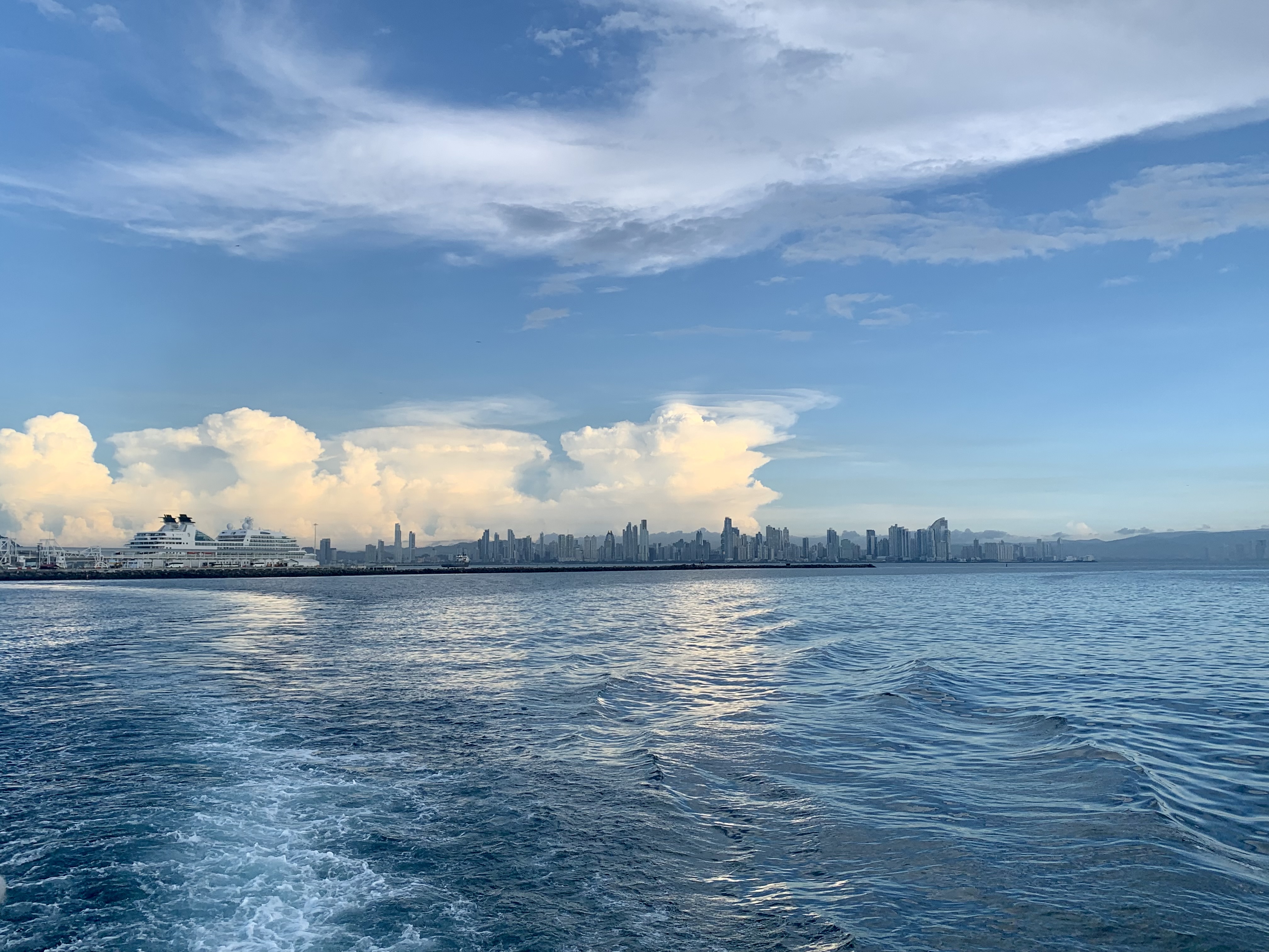
| Panorama of the Panama skyline. |
After our walking detour, we headed back to Panama City to a store that I had read about prior to coming to Panama: Karavan Gallery. Started in 2008, the gallery sells crafts made by Panamanian artisans. The shop itself is small but carefully curated with high quality masks, sculptures, pillows, and more. Of course, I instantly fell in love with two huge pieces. My mom kept saying to only get one, but who do you think won that debate?! Hint: me (somehow convincing my mom that we could in fact carry these on the plane as carry ons)... So we bought two gorgeous bird sculptures.
 |
| I instantly fell in love with this toucan sculpture, which is all hand woven with natural materials. |
 |
| This massive parrot sculpture called my name and I knew we had to have it! Mom was not thrilled at the size of this one... but it did make it home safely! |
After a very long day, we headed back to the hotel for dinner and sleep. The following day, we woke up early to have our only breakfast at the hotel. I opted for eggs Benedict on fried bread, which was unlike anything I'd ever had before.
 |
| My tasty breakfast. |
While many people visit Panama solely for the canal, it is so much more than that and I wish we had more time to discover its abundant bird life (over 900 species have been recorded in Panama!), its endemic orchids, the beaches, the islands, the national parks, the coffee region, and so much more. Aside from the canal, we unfortunately only saw a little bit of what Panama has to offer by visiting an Emberá community. The Emberá are a pre-Colombian Indian native group living in the Darien, the last jungle stronghold separating the Americas. It was declared a UNESCO site in 1981 and designated as a Biosphere Reserve in 1983. The Emberá occupy an autonomous district and the community members farm, fish, and produce handicrafts for a living. They're outstanding sculptors of wood such as cocobolo and tagua ("the vegetable ivory") and they create mini sculptures to sell to the tourists who visit, among intricately woven masks and baskets. The Emberá have populated the Choco region of Western Colombia and the Darien region of eastern Panama for centuries, long before Spanish colonization. Today over 30,000 Emberá inhabit Panama and while most still live in the Darien region, some communities such as the one we visited have migrated to Chagres National Park between Panama City and Colon, allowing for more accessibility to tourism. While no roads go through the Darien Rainforest into Colombia (all the travel is still done by shallow dugout canoes), we were able to drive to a launch point (there's not even a formal dock) and we took a canoe across to the community.
 |
| Sailing away from where the boats "dock". There's no formal dock, so the bows of the dugout canoes are run ashore and you step over the benches to load up from the back forward. |
 |
| Taking a short canoe ride to the village. These were fancy canoes with motors, though we did see some that are still operated by hand. |
The Emberá traditionally live on the edge of the river (ideally where two rivers come together) and high enough on the riverbank to avoid floods. As such, they're accustomed to having easy access to fresh water for drinking, cooking, and bathing. The houses are ideally suited to the tropical climate with living quarters built on a wooden platform anywhere from 4-12 feet off the ground for protection from the elements as well as wildlife. Palm fronds are thatched together to complete the roof and there is a hole in the roof for kitchen smoke to escape from while cooking.
 |
| Pulling up to the village. |
 |
| One of the traditional buildings. |
 |
| Entering the main area. |
We were greeted by the chief, who welcomed us into one of the traditional common areas for a presentation while lunch was cooking. He told us about the history of the Emberá, how they make handicrafts, and their social structure/traditional ways of life. He spoke a little of the local indigenous dialect so we could hear how different it was from Spanish, and then spoke in Spanish with our guide translating to English.
 |
| The chief shows us a map of the different areas of the Emberá. |
The staple crop of the community is plantain, and a traditional meal always includes plantains accompanied by fresh fish from the river (whatever fish is caught that day). We were treated to this traditional meal as soon as the presentation was over.
 |
| Preparing lunch. |
 |
| Lunch was served in leaves and we ate with our hands-- It was delicious! |
 |
| Smashing more plantains to fry them. These were my favorite, and I ate way too many!! |
 |
| Fresh fried tilapia from the river, plantains, and beef that was similar to a beef jerky. |
 |
| Our guide's wife made us homemade beet hummus to take with us. It was the best we've ever had! |
Unfortunately, the Emberá are being squeezed out of their traditional living areas by encroaching ranchers, loggers, and miners, and it's becoming more difficult to find the plant materials needed for basket weaving to sustain themselves financially. Additionally, in order for their children to go to school, many Emberá have since left their isolated homes in the Darien in favor of moving into villages/cities closer to modern day facilities. Nevertheless, it's remarkable to think that even with their centuries of isolation on the riverbanks, they've managed to cope with the outside world. Since the 1980s, their skills as artisans have provided accessible means for them to earn money. They sell directly to tourists or to fair trade stores in other cities (like the Karavan Gallery that we went to), and their baskets are treasured among collectors. The baskets are made from young leaves of chunga and nahuala (Panama hat palm) and the outer layers are peeled away to reveal a wide, inner strip of fiber which is then cut into narrow strips to dry. The strips are washed and bleached in the sun to create a strong fiber as fine as thread. The colors are all natural and are made from fruits, leaves, wood shavings, roots, ashes, mud, and many other resources found in the surrounding rainforest. Some designs might be pictorial, depicting wildlife of the Darien, whereas others might appear more abstract. In the major towns, prices tend to be marked up but still fair considering the amount of time it takes to make one basket or mask and due to the fact that local shops profit in addition to the Emberá who make the crafts. In the villages, however, prices depend on the number of days it takes to make the handicraft. If it takes a woman 10 days to create a basket, regardless of how many hours spent working on it per day, chances are it'll be $10 USD. Of course, we went crazy when we saw 10+ tables of handicrafts and wanted to buy every basket there to add to our collection at home. We restrained ourselves and made it out with three small, easy to pack baskets and a small jaguar mask.
 |
| Mom with the woman who made her basket. |
 |
| The small baskets we bought. |
 |
| The jaguar mask I bought. |
After a brief dance party (in which the chief asked me to dance, and how can I say no?), we made our way back into the canoes before the afternoon rain that this particular region of Panama is known for. Once the rain starts falling, it becomes dangerous to drive on the curvy roads with the heavy rainfall.
 |
| Getting ready for a brief performance. |
 |
| Me and the chief. |
 |
| Getting back into the canoes. |
When we got back to the car, we made a detour to a coffee shop for a quick caffeine fix (and to eat more empanadas, duh).
 |
| We had a chicken empanada and one filled with figs and cheese. The latter was my favorite! |
We proceeded to return to the Panama Canal for a different viewpoint... This time, we'd be seeing the canal from above from the Miraflores Visitor Center at the lock gates we had passed through the day prior. While it was incredibly crowded, we were able to see the locks from a different angle (when tourists weren't shoving their phones in front of us at least).
 |
| Close up of the control tower. |
 |
| One lane of the canal. The other lane is on the other side of the control tower. |
 |
| Unfortunately, the ship passed through the other side. It was already very late in the day and these were some of the last ships coming through. |
Right as we were leaving the Miraflores Visitor Center, the rain started coming down in buckets. We drove back to the hotel, rested, repacked, and had an early dinner before leaving for the airport bright and early for our 7 AM flight back home the next morning. We said "see you later" to Panama, because we know we'll be back. It's become one of our all time favorite countries.
 |
| Flying over Panama. |
Of course, when we got home, we immediately unpacked and started decorating the house with our purchases. Of all our trips over the years, I think this trip was my favorite for shopping. We came back with beautiful masks from Guatemala and Panama, weavings from Guatemala, baskets from Panama, and more.
 |
| All our goodies... |
We had fun creating a Panama table with all our goodies from the Emberá!
 |
| Decorating! |
The trip might have started off a bit rocky in Guatemala, but it certainly ended strong in Panama. It was the perfect last-minute Thanksgiving escape but left us exhausted and in need of a vacation from our vacation since we had jam-packed so much sightseeing in to a short amount of time. The good news is, we're off on our next adventure in February! Thanks for following along with our adventures in Guatemala and Panama. As always, follow my Instagram @elissatitle for photos, and stay tuned for more. Wishing you all a very Happy New Year and a happy and healthy 2023.


Comments
Post a Comment