Located
approximately 150 miles north of the Arctic Circle, the ilulissat icefjord is
the sea mouth of Sermeq Kujalleq, one of the fastest moving active glaciers in
the world. Annually, it calves over 35 km3 of ice (10% of the
production of all Greenland calf ice and more than any other glacier outside
Antarctica). At its eastern end is the Jakobshavn Isbræ glacier, the most
productive glacier in the northern hemisphere. The iceberg calves off around 20
billion tons of icebergs every year! Studied for over 250 years, this icefjord
has helped to develop our understanding of climate change and icecap
glaciology.
The icefjord was
declared a UNESCO World Heritage Site in 2004. Today, we got to hike the
icefjord in Sermermiut. Two kilometres south of Ilulissat, Sermermiut was once
amongst the largest settlements in Greenland with around 250 inhabitants. The
hike began with a long, never ending, wooden platform pictured below.
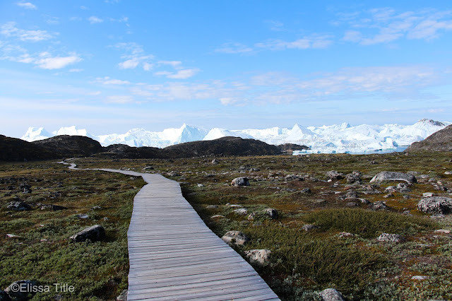 |
Pathway to the end of the boardwalk.
|
|
As we hiked up and down the hills on this wooden platform
(so tourist traffic doesn’t ruin the tundra), we could see glimpses of large
icebergs.
 |
| The trail took us through the mountains and up a hill to a lookout. |
|
 |
On the way to the lookout, this was the view.
|
|
At one point, we came across a bronze plaque that read “You are now entering
the UNESCO World Heritage Site of Ilulissat Icefjord).
 |
| A bronze plaque stating that we are entering the UNESCO site. |
After hiking up some steps, the path ended and we were left
to hike on the steep, jagged rocks. Our guide warned us to be extremely careful
on this terrain. Hiking around at the top of the mountain was stunning. We were
treated to panoramic views of the icefjord which covered with ice.
 |
Stairs to the end of the boardwalk.
|
|
 |
Hiking along the cliffs, overlooking the icefjord. You can see how small the person on the right is in comparison to the ice!!
|
|
 |
| Since I'm always behind the camera, I figured I'd ask someone to take a photo of me. |
 |
| And another one, because this is my favorite landscape in Greenland thus far. |
Instead of taking the bus back (which is how we came to the
hiking trail), we walked because I wanted to photograph Greenlandic dogs. These
dogs are working dogs and are kept outside 24/7 even in the harsh winter
climate. The dogs are used for hunting and fishing pulling sleds and people.
Here are some of my favorite photographs…
 |
Walking back from Sermermiut through large fields filled with dog houses.
|
 |
A dog sits on top of its dog house in the open fields. They're left outside 24/7 and currently aren't working (they are only put to work in the winter).
|
 |
Now, the dogs are super lazy since they don't have to work for awhile!
|
|
We were told the walk back to town would take 15 minutes,
but locals must walk really fast because it took nearly 45! This was the
hilliest town we’ve been in. I frequently stopped for photo breaks, taking in
the beautifully colored houses and architecture. I even stopped for this cotton
grass, which literally looks like cotton balls blowing in the wind.
 |
Cotton grass on the side of the road.
|
|
The town of Ilulissat is the third largest settlement in
Greenland with a population of 4,453 (plus nearly 2,000 working sled dogs). The
town’s name directly translates to “The Icebergs” in Greenlandic, and after
that hike I can see why. After nearly 4 hours of hiking, we arrived back at the
ship.
That's all for now... Stay tuned for more
Greenland/Iceland/Canadian High Arctic adventures. Also, be sure to hit the
subscribe button to be notified of new posts, as there is sometimes unreliable
internet! Follow my instagram @elissatitle for more photography posts.


.jpg)


Comments
Post a Comment