 |
| Župa Svetog Ivana Apostola i Evanđelista, a Catholic church in Mostar. |
 |
| Remnants of a bombed out building mixed with the new, restored architecture of the city. |
The town's Old Turkish quarter is a UNESCO World Heritage Site and includes the city's most iconic landmark: Stari Most. Stari Most is an Ottoman style bridge built on the orders of Suleyman the Magnificent. The bridge gets its name from the bridge-keepers (mostari) of the wooden bridge, as Mostar had a key position on the trade route between the Adriatic and mineral-rich central Bosnia (which led to growth along the river). Mostar became the leading town in the Herzegovina region and after invasion by the Ottomans in 1468, the center of Turkish rule in the area. The city became part of Austro-Hungary in 1878 and the administrative buildings of that period have neoclassical and secessionist features. Bosnia and Herzegovina declared independence from Yugoslavia on March 1, 1992 which triggered a secessionist bid by the country's Serbs and a war that left over 100,000 dead. The core conflict was a territorial battle between the Bosnians, Serbs and Croats. The war is often portrayed as ethnic, but all sides were Slavs differing only in their generally secularized religious backgrounds-- Bosniaks were Muslim, Serbs were Orthodox Christians and Croats were Catholic. In Mostar specifically, Bosnian Croats and Bosniaks traded fire across a front line.
 |
| Overlooking the Koski Mehmed-Pasha Mosque from Stari Most. |
The original bridge structure was destroyed during the conflict of the Bosnian War when, on November 9, 1993, the Old Bridge of Mostar was destroyed by shells fired by Croatian gunners amid fierce fighting with Bosnian Muslims. In July 1995, Dutch peacekeepers proved unable to prevent a Bosnian Serb force from killing 8,000 Muslim men in Europe's worst mass killings since WWII and two weeks of NATO air strikes in September 1995 added force to an ultimatum to end the Serb's siege of Sarajevo. A peace conference was held in Dayton, Ohio and the Dayton Peace Accords were signed in late 1995, achieving the immediate purpose of putting an end to the bloodshed and conflict though ethnic divisions froze in place. The resultant accords maintained Bosnia and Herzegovina's pre-war external boundaries but divided the country into semi-autonomous entities maintaining fragile peace. Even now, the complex political structure (with over 60 political parties) has led to bureaucratic tangles and economic stagnation.
 |
| Stari Most in Mostar. |
But, back to the bridge... Mostar's bridge was rebuilt largely from the original stones and it was unveiled in 2004, becoming a symbol of postwar reconciliation, international cooperation, and the coexistence of different cultural, ethnic and religious communities. Fast forward to the present day, and you have no idea whether you're on the Muslim or the Croat bank of the Neretva River... The imaginary dividing line running through the center of the city during the war of 1992-95 only exists in the minds of the people. Crossing the Stari Most bridge into Old Town, we looked out towards the Koski Mehmed-Pasha Mosque.
 |
| Koski Mehmed-Pasha Mosque as photographed from Stari Most. |
Following the slippery, limestone streets, we made our way towards what is considered the most beautiful viewpoint in Mostar. From the Koski Mehmed-Pasha Mosque, we looked out towards the bridge. It is here that most of the postcard photographs are taken.
 |
| Stari Most as seen from the Koski Mehmed-Pasha Mosque. |
 |
| Our little photo nook. |
 |
| Smiling through the rain. |
 |
| Smiling through the rain, while prioritizing my camera gear over myself. My camera gear was hidden under my rain jacket and waterproof bag. I still got wet, but at least all my equipment was dry! |
Just as we got here, it started to rain and not just rain... POUR. After taking some last photos of this picture perfect bridge with the brilliant turquoise waters, we made our way into the mosque. Entering through a gated courtyard, the mosque (built in 1618) has a dome painted with botanical motifs and vibrantly painted glass windows. Damaged by Croatian military forces during the Bosnian War, the mosque was restored from 1996 to 2001.
 |
| The ceiling of the mosque, complete with vibrant windows. |
 |
| Inside of the mosque. |
Exiting the mosque with our left foot forward (it's tradition to enter with your right foot forward and exit with your left foot forward), we ducked back into the rain to visit a traditionally Turkish home. We entered through a doorway which opened up to a courtyard. The Turkish House is a preserved late 16th century Ottoman nobleman's mansion (once the home of Mostar's Turkish governor). The fountain courtyard garden is pebbled in a circular pattern representing the five daily prayers of an observant Muslim. Crafted from stone, the two-story house is white with an overhanging roof that shades the lower floors.
 |
| Courtyard of the Turkish House. |
 |
| Courtyard of the Turkish House as seen from the second floor. |
Inside, the house is furnished in its original form with separate living quarters for men and women, brightly patterned kilims (a flat tapestry-woven carpet or rug traditionally produced in countries of the former Persian Empire, Iran, Azerbaijan and Turkic countries of Central Asia meant to be used for either decoration or as a prayer rug), traditional sofas, and ornately carved wooden furniture.
 |
| Turkish coffee set up. |
 |
| The perfect window seat. |
 |
| Traditionally decorated Turkish home with ornate wooden furniture and brightly decorated furniture. |
After exploring both levels, we headed out in the rain to make our way towards lunch.
 |
| Walking through Old Town with storm clouds looming overhead. |
Of course, I stopped for some more photos of Stari Most along the way (while trying not to slip and fall on the wet limestone).
 |
| Stari Most as seen from a viewpoint. |
 |
| Stari Most as seen from the end of the bridge. |
 |
| The floor of the bridge has limestone with elevated blocks, making it a little easier to walk on while wet. |
Crossing the bridge once more, we continued along the cobbled paths.
 |
| Entrance/exit to Old Town via Stari Most. |
After lunch, we boarded a quick 15 minute flight (probably the shortest airplane ride of my life) for Sarajevo, the capital of Bosnia and Herzegovina. So how did a country of just over 31,000 square miles get such a long name? Well, it's complicated as is the country's past. The name is believed to have derived from the hydronym of the river Bosna while Herzegovina originates from Bosnian magnate Stjepan Vukčić Kosača's title "Herceg (Herzog) of Hum and the Coast". Hum was an early medieval principality that was conquered by the Bosnian Banate in the first half of the 14th century during which time the region was administered by the Ottomans within the Eyalet of Bosnia. On initial proclamation of independence, the country's official name was the Republic of Bosnia and Herzegovina but following the 1995 Dayton Agreement and the new constitution, the official name was changed to Bosnia and Herzegovina. Today, Mostar is considered to be in the Herzegovina region whereas Sarajevo is considered to be in the Bosnia region, though both cities are part of the same country (Bosnia and Herzegovina is one country, not two).
 |
| Flying to Sarajevo. |
 |
| Flying over a rainbow on the way to Sarajevo. |
Like Mostar, Sarajevo was besieged and on the edge of annihilation in the 1990s. Since the war, it has been restored and the historic center is full of cafes and hotels, though bullet holes are still evident in the city's architecture. When we reached our hotel, we headed out on our balcony for panoramic views of the city and surrounding mountains.
 |
| View from the room. |
When we got to the room, slippers from BH Crafts were waiting on the bed for us. BH Crafts produces handmade clothing and decorative items, all crafted by women from Bosnia and Herzegovina. After the war, BH Crafts began as a humanitarian enterprise since they believe women are among the greatest victims in any war (thousands of women lost their husbands, their families, their homes, and were left to raise their surviving children any way they could). BH Crafts confronted this trauma by giving the women skills and opportunity to move forward and has since employed more than 500 women of all ethnicities.
 |
| Slippers! |
Dropping our bags off in our room, we briefly headed out to Klopa, about a 7 minute walk away, for dinner. Klopa is a slang word for food in Bosnian and means really good food. Surrounded by real flowers, a wooden interior and lively colors, dining here was like sitting in an outdoor garden.
 |
| Local Bosnian beer. |
 |
| Lamb chops, which were written up in Lonely Planet. |
After eating dinner at Klopa, we headed to bed for an early morning of touring. Instead of doing the group city sightseeing, we decided to go on a hike. Prior to coming to Bosnia and Herzegovina, I had researched places to photograph. The old, abandoned Olympic bobsled and luge track seemed to be the top "off the beaten path" photography location, and something we both wanted to see. While you can take a taxi or cable car up to the track, we had found an article with walking directions and so we decided to walk. Little did we know, it would turn out to be the adventure of the trip.
 |
| Unintentionally matching for our hike. |
We followed the instructions provided by "Two Scots Abroad". For the most part, the directions were great. We inputted the GPS coordinates 43°50′28″N 18°26′32″E into our phone and saw the general direction we needed to go from our hotel, Hotel President. We crossed the river and followed Bistrik street uphill for what felt like forever. Up, up, up we went, passing by local shops.
 |
| Walking on Bistrik. |
We piggy backed off some free wifi to make sure we were headed in the right direction (which we were) and we continued further uphill before we arrived at a staircase. We went up...
 |
| Going up the steps. |
We continued further uphill past locals sitting on their patios.
 |
| Taking a water break. |
 |
| Up, up we go... |
At one point, we came across a fork in the road. We didn't know which way to go since there were no street signs and we must have looked very confused because two local Bosnian men came up to us. While we didn't speak a word of Bosnian and they didn't speak a word of English, we were able to communicate with hand gestures and they told us to take the left fork and climb uphill. We smiled and waved goodbye, taking the left fork up some more. Per the blog's instructions, we noticed a grassy patch to the right with some cars parked there. We turned right and reached a natural path.
 |
| Heading off the pavement. |
We continued our steady uphill climb. We noticed a tree line way off into the distance and at that point, we assumed we were heading there.
 |
| Still looking happy. |
The path became steeper and steeper as we neared the top of the tree line. Alone in nature, we did not see one other person the entire time we were hiking.
 |
| Hiking up a narrow, steep, path. We were the only ones on the entire hike. |
 |
| Views while going up the mountain. |
 |
| Getting closer to the top. |
We climbed some more, taking in the panoramic views.
 |
| Hiking up some more... |
 |
| Climbing up while balancing camera gear. |
Towards what appeared to be the top of the mountain, we reached the steepest part of the hike.
 |
| Steepest stretch. |
 |
| Fauna along the hike. |
 |
| Looking back down towards the city. |
After a final push uphill, we came across a muddy patch. Even if we ventured off the trail into the grass ever so slightly, we could not avoid the mud.
 |
| I'm pretty sure my shoes are forever ruined. |
After even more uphill climbing, we finally reached some bombed out houses covered in graffiti. We walked around, creeped out by the fact we were standing where a bomb went off not too long ago... In our lifetime even.
 |
| Bombed out house on the top of the mountain. |
 |
| Two bombed out houses covered in graffiti. |
 |
| The walls on this building were totally knocked out. |
 |
| Looking through a window, where nature has taken over the interior. |
 |
| Nature has begun to take back the ground, with trees sprouting up through the houses. |
 |
| One of three abandoned buildings on the hill. |
 |
| Looking up through the window of one of the houses. |
 |
| The most intact building. |
 |
| View through the bombed out side of the building. |
This elevated point was supposed to be 20 minutes away from the track but here, all hell broke loose... As the GPS coordinates only got us to the start of the hiking trail in Dolovi, we followed the rest of the instructions based on photos and directions written in the blog post. While it said "to the right of this (cat graffiti building) is a path, head along it then up, you'll meet a paved road which curves up to the left, more abandoned houses then... you've reached Sarajevo's bobsled track location", the picture was taken from a weird angle. We positioned ourselves in the location the photo was taken and looked to the right. We saw a paved road slightly down the mountain, and as we were surrounded by trees in every other direction, headed downhill (red flag number one, because that doesn't really make sense).
 |
| Heading towards the road. |
After a little Sound of Music moment, we reached the paved road. We saw a path that curved up to the left, so we followed that per the instructions... We thought. However, that path ended. Now, we were stuck. We turned around and followed the main road, paralleling the cable car. We could see the top of the mountain we needed to be on, but now we had no idea how to get there.
 |
| When in doubt, follow the cable car. |
We came across some locals who spoke a little bit of English. We were so relieved, and asked them how to get to the bobsled track. Uh oh! They didn't know about this bobsled track, the Olympic luge track, or however else we phrased it. So much for that. They wished us good luck, and we continued on. At this point, we were struggling to make it uphill. We had been hiking for over two hours and we were getting really frustrated. In my mind, I was considering turning around, going back to the hotel, and taking a taxi up to the track. Suddenly, I hear "Ummm Elissa, we're back in the same place". Sure enough, we were back at the bombed out buildings but on a different path. We decided to check out where this path went, and suddenly I hear an excited cry, "I SEE A SIGN!!!". I got to the top of the hill and saw a bright red sign. How could both of us have missed this? According to the directions, we were supposed to head to the right and pass more abandoned houses... houses being plural. At the top of the mountain, there were only three houses, two to the left and one to the right. Had this been worded differently, we probably wouldn't have gotten turned around. Exhausted and excited, we followed the signs. This part of the hike was supposed to take about 20 minutes.
 |
| Bright red sign directing us to the track. |
To the right of the sign and through the tree, you can see the houses we were at.
 |
| Bright red sign. Through the tree on the right, you can see the building where we were. |
Shocker... We now had to climb further uphill as we followed the signs.
 |
| Continuing along the path. |
Finally I heard, "I SEE IT!!". We had made it to the bobsled track, only it was different than what I had seen in photos. I was expecting a graffiti paradise but instead, we were met with a track in the middle of the forest with overgrown trees... and no graffiti.
 |
| Part of the Olympic bobsled track. |
Confused and very disappointed, I looked in all directions in search of the graffiti. I saw nothing.
 |
| The bobsled track extended for what looked like forever. |
I had seen photos of people walking on the track but as this section was a bit high to climb over, we continued along the paved path to the left.
 |
| Walking near the bobsled track. |
We eventually came across a road on the right, and followed that. It's a good thing we couldn't hop over the wall of the track because when we looked down towards the track, we saw that an entire section had been broken off.
 |
| What we thought was the end of the track. |
Extremely disappointed now, we continued further uphill. We saw a path curving down to the right and because we were tired of going uphill, decided to go on the downhill path on the righthand side. After a few minutes, we reached a clearing... more of the track.
 |
| More of the bobsled track. |
We ran down the hill and peered over the curve's edge... THIS is what I had seen in photos. We had finally found the graffiti. I began reaching over the edge, taking photos with my wide angle lens.
 |
| Happy to finally have found the track. |
 |
| The curve of the bobsled track. |
 |
| A graffiti paradise. |
I had done some Instagram stalking beforehand and noticed that people were walking on the track. Not seeing any police, we too hopped on the track (hoping it was still stable... We were relieved when we saw a handful of other people walking on the track a bit further down).
 |
| Walking on the Olympic bobsled and luge track. |
Of course, I had to take a touristy pic... Watch out! Elissa is coming in first place!!
We continued along the path, admiring the vibrant colors of the graffiti. At one point, we came across "BOSNIA" written out and on the top of each letter, S-E-R-B-I-A.
 |
| Bosnia graffiti. |
 |
| Selfie at the Olympic track! |
Less than a decade before the Bosnian War and the Sarajevo Siege, Sarajevo hosted the 1984 Winter Olympics. Many of the sports venues were damaged in battle and the bobsled track was used by the Bosnian Serbs as a base for artillery during the Sarajevo Siege from 1992-1996.
 |
| Everywhere we looked, we came across graffiti. |
 |
| Lex standing for scale. |
 |
| Getting a lower perspective. |
Hidden by nature, the track sits at the top of Mount Trebević (with an altitude of 5,338 feet). While the bobsled track continued uphill, we noticed the track became raised further off the ground. Concerned about stability, we hopped back over the railing and back onto the paved trail.
 |
| Following the trail, paralleling the bobsled track. |
We saw other people walking along the elevated track, but as we rounded the corner we noticed just how high off the ground it was. Even if we had walked on the track, we wouldn't have been able to get down without jumping or turning around the way we came.
 |
| Panorama of the bobsled track. |
 |
| Bobsled track in the middle of the overgrown forest. |
Tired from our long hike, we decided we'd take the cable car down (not knowing exactly where in the city it went). We continued on the path... You guessed it, further uphill! The path went under the cable cars, and we looked to our left. For the first time since finding the track, we could see how high above the city we had actually climbed.
 |
| Sarajevo city below. |
After some more uphill climbing, we finally reached the cable cars.
 |
| Cable cars at Mount Trebević. |
 |
| Happy to be sitting down!! |
As our cable car descended, we caught a glimpse of the bombed out houses we had seen earlier. For a better sense of scale, here's an iPhone photo without zoom...
 |
| Bombed out houses we had walked by earlier. |
And now, a more zoomed in photo with my camera...
 |
| Bombed out houses and the hill we went down. |
As we descended further, we could see the hill we had climbed down and the paved road we had climbed back up. The tall trees blocked our view of the abandoned houses when we were walking uphill, so we didn't know how close we were to the buildings until our cable car ride.
 |
| The path we had climbed back up. |
High above the city, our cable car descended over neighborhoods and trees.
 |
| Views from the cable car. |
 |
| Views from the cable car. |
As we reached the bottom we caught a glimpse of Vijećnica, Sarajevo's City Hall.
 |
| City Hall from above. |
Finally at the bottom of the mountain, we now had to find our way towards the river. Thanks to the panoramic views from the cable car, we already knew which way to go. As we walked downhill, it started to rain... We were very relieved we didn't decide to hike down the mountain!!
 |
| Walking downhill towards the river. |
By now, it was already past 1pm (and we had left the hotel around 8:30am). We were hungry and craving pizza, so we walked back to Klopa knowing we'd get good food, fast service and friendly waiters who spoke fluent English. We also had their berry iced tea which was amazing!
 |
| Celebratory meal at Klopa. |
When we got back to the hotel, we looked at the view from our balcony to find that the mountain we saw from the room was the mountain we ended up summiting.
 |
| We hiked to the top of the tree line! |
Exhausted, we relaxed a little before our group dinner at Vijećnica. The Neo-Moorish facades make the 1898 City Hall Sarajevo's most beautiful Austro-Hungarian era building. Like many other buildings, it was seriously damaged during the 1990's siege and reopened in 2014 after reconstruction. Upon entering, the first thing you notice is the gorgeous octagonal shape with a colorful stained glass ceiling.
 |
| Inside of City Hall. |
Before our dinner upstairs, we were treated to some local dancing.
 |
| Local dancers at City Hall. |
When the performance was over, we made our way upstairs where we got an even more complete view of the perfectly symmetrical architecture.
 |
| Stunning architecture of City Hall. |
 |
| Architecture of City Hall as seen from the second story. |
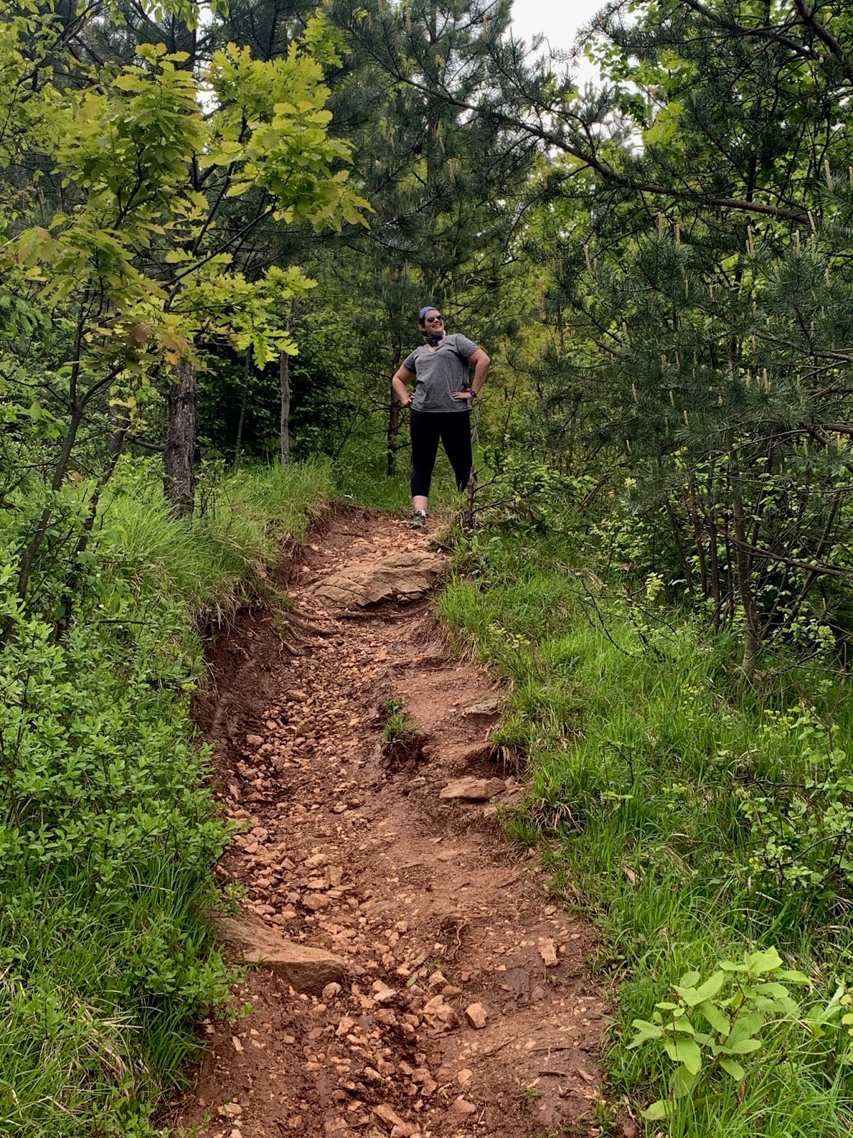
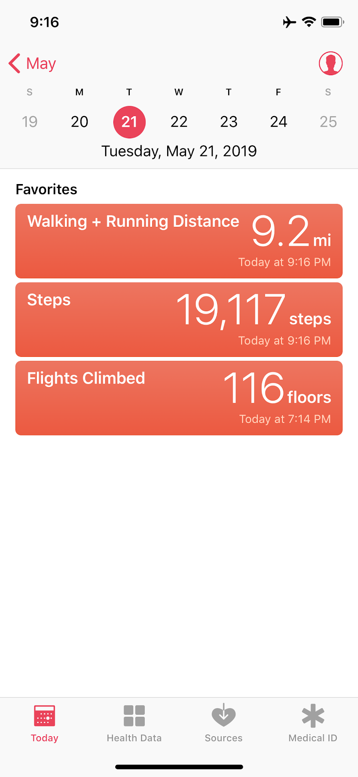
And, by the end of the day, it was safe to say we had gotten our steps in!!!
After dinner, we headed to bed to prepare ourselves for our flight to Ljubljana, Slovenia. I have to say, I was pleasantly surprised by our time in Bosnia and Herzegovina and wish we had stayed longer. With the region's dark history, I wasn't sure what to expect. I certainly wasn't expecting a beautiful city surrounded by green mountains. Bosnia is stunning, and I hope to visit again one day.
Thanks for reading about my latest adventures. Stay tuned for what's to come and be sure to hit the subscribe button on the homepage to be notified of new posts. As always, follow my instagram @elissatitle for more pics.


Comments
Post a Comment